Showing posts with label weather. Show all posts
Showing posts with label weather. Show all posts
Wednesday, 20 March 2019
Lovely first day of spring
This morning has a beautiful blue sky, a nip in the air but prospects for a spring equinox under the sunshine. Meteo France recognises tomorrow, 21st March, as the start of spring, whereas the UK Met Office says today. Let's mark both with a walk in the country, an hour in the garden (or, as in our case) a trip to the dechetterie.

Wednesday, 30 January 2019
Nasty weather about
Whilst most of us in the Midi Pyrenees region were subjected to a wet and sometimes windy day many parts of the country suffered either very high winds or significant snowfalls. Departments still with alerts are mainly in the east though people heading for the northern ports could encounter delays around the main towns en route.
There was heavy snow in the mountains and the massif around Laguiole, so skiing trips may well be worthwhile in the February holidays.
Milder days seem to be on the cards for us, though still some rain and wind are in prospect. Motorists are advised to check with the traffic info on the radio, or via the social media sites which provide up to date information.
There was heavy snow in the mountains and the massif around Laguiole, so skiing trips may well be worthwhile in the February holidays.
Milder days seem to be on the cards for us, though still some rain and wind are in prospect. Motorists are advised to check with the traffic info on the radio, or via the social media sites which provide up to date information.
Thursday, 24 January 2019
Snow round about
When we said no snow in the forecast for a week (see Wednesday), obviously the weather had other ideas. At Mas del Sol we are 310m above sea level and there is much higher ground in the vicinity and some readers have pointed out that they have lots of snow. These photos from MdS show that the hills beyond the Aveyron and above Ginals have had a fair amount these last two days. There is some snow in the forecast for early next week, so stock up on essentials if needed.
 |
| Hills above Lexos towards Vaour |
 |
| Hills above Verfeil/Ginals |
Wednesday, 23 January 2019
Snow horses
Woke again with a horse missing. Just what we wanted to avoid when the donkeys left, as they were adept at escaping when there was little food left in the field. Fortunately when it was light old Mario was spotted in a neighbouring field and led back to the enclosure.
Happily it was not snowing this morning (though the rain was cold), whereas yesterday afternoon we had a decent shower of snow, forcing Mario to hide in the cabin, leaving poor Margaux to brave the elements.
No snow is forecast for this area for the next seven days.
Happily it was not snowing this morning (though the rain was cold), whereas yesterday afternoon we had a decent shower of snow, forcing Mario to hide in the cabin, leaving poor Margaux to brave the elements.
 |
| Pic Malcolm Johnstone |
Monday, 7 January 2019
2018 had lots of weather
We all witnessed an exceptional year of weather, the most notable being the long hot drought. In fact Meteo France says it was the hottest year on record with an average temperature of 14ºC, some 1.4ºC above the norm. This placed it as the hottest year since the year 1900, beating 2014 and 2011. There was also a record run of 9 consecutive months above average. The drought has been recognised as an exceptional event and we at Mas del Sol actually had a taxe fonciere refund (all of 24 euros) owing to a loss of crops from our one field.
We can also attest that the year was exceptional in the number of lightning strikes experienced. There were 296 days when there was a storm and over 725000 strikes. Apparently May was particularly bad, our house being hit on May 7th by one of the 182125 impacts - three times the normal.
Storms were often accompanied by violent rain or hail storms. The storm which hit Bordeaux on 26th May dumped 22mms of rain in 6 minutes (one inch of rain is about 25mms).
Still, no such thing as global warming.
We can also attest that the year was exceptional in the number of lightning strikes experienced. There were 296 days when there was a storm and over 725000 strikes. Apparently May was particularly bad, our house being hit on May 7th by one of the 182125 impacts - three times the normal.
Storms were often accompanied by violent rain or hail storms. The storm which hit Bordeaux on 26th May dumped 22mms of rain in 6 minutes (one inch of rain is about 25mms).
Still, no such thing as global warming.
Wednesday, 10 October 2018
Tarn church tower struck by lightning
 |
| photo DDR Br.M |
Sunday, 12 August 2018
Beware of storms later today
Meteo France has issued an orange alert for storms from 16h today (Sunday 12th August), with possibility of hail, heavy rain and strong gusts of wind.
Departments covered are mainly to the west, but include Tarn and Garonne. The risks extend into the early hours of Monday, but will gradually fade.
comments to taglines82@gmail.com
Monday, 22 January 2018
Nous sommes le lundi vingt deux janvier
The rivers are all flooding in Laguepie, Varen, St. Antonin and Najac, everywhere round about we are out taking photos... usually in the rain. The first two pictures Laguepie and the last one of Varen


The good news is the weather is set to change from tomorrow.
taglines82@gmail.com
Saturday, 20 January 2018
Missing the sun?
According to weather experts at various Meteos in Europe we have been missing sunshine this month. We think we had noticed! Apparently Brussels had only 10 hours sun in the whole of December (average is about 60 hours). In the first half of January, Lille has seen 2 hours 43 mins of sunshine and even here in the South west Toulouse basked for only 27 hours against an average of 92, with a similar score for Marseille. "Sunlight therapy" outlets are doing well in the north of France and here we are forecast plenty of sun towards the end of next week.
But spare a thought for the inhabitants of Moscow, where the meagre 6 minutes of sun in the whole of December has probably added to their legendary gloominess. At least they had Mr Putin swimming in freezing waters to encourage them - what price M Macron?
comments to taglines82@gmail.com
Thanks to Tony Coles for the link to The Guardian
But spare a thought for the inhabitants of Moscow, where the meagre 6 minutes of sun in the whole of December has probably added to their legendary gloominess. At least they had Mr Putin swimming in freezing waters to encourage them - what price M Macron?
comments to taglines82@gmail.com
Thanks to Tony Coles for the link to The Guardian
Sunday, 31 December 2017
Windy day for 2018
Despite this morning dawning bright and sunny, the wind is noticeable (if mild). But it may increase steadily and tomorrow quite damaging gusts may mark the afternoon and evening. A storm called Carmen is expected to sweep up the west coast, with severe gusts up to 120kph causing floods and damage. Here in the south west we should miss the worst (unless you are on a mountain top), but still may see 60-80 kph gusts.
As storm Dylan is battering the UK perhaps staying put might be the best way to welcome 2018.
comments to taglines82@gmail.com
As storm Dylan is battering the UK perhaps staying put might be the best way to welcome 2018.
comments to taglines82@gmail.com
Friday, 29 December 2017
Avalanche risk in Pyrenees
Those of you aiming to go skiing in the mountains over the New Year are warned that there is a serious risk of avalanches. Several ski resorts have been closed since Thursday, after heavy snow and gale force winds earlier in the week, followed by rain on Thursday. The risks are enough to trigger orange alerts in several departments.
comments to taglines82@gmail.com
comments to taglines82@gmail.com
Friday, 22 December 2017
Guess what? It's winter
Meteo France takes 21st December as the official start of winter (unlike the Met Office in the UK which appears to use 1st December). But 21st December is also the winter solstice, the shortest day following the longest night. So imperceptibly at first the days are getting longer; 4 seconds added today, 10 tomorrow and 16 by Sunday. Historically the winter temperatures have varied from -20º in 1985 to 29ºC in 1960. Current temperatures are apparently normal for the season and winter is forecast to be mild and warmer than average in the southern part of France. Winter will end on 21st March.
comments to taglines82@gmail.com
comments to taglines82@gmail.com
Monday, 11 December 2017
Meteo
The editor did not have time to comment on the weather, and for most of us locally it is a dull, damp and relatively mild start. There are even "sunny intervals" forecast as the rain turns to showers.**
But for most of France there are weather warnings: snow; ice; high winds; flooding. Over 30 departments are on orange alert as storm Ana passes by in the north west. But the high ground may also suffer gale force winds, including most Pyrenean heights.
Meteo France says the depression is almost as deep as that of 1999, when millions of trees were destroyed. and a glimpse of our barometer this morning shows how the pressure has dropped.
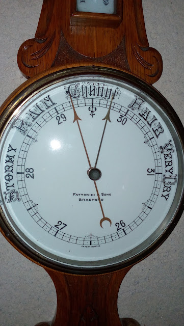
But for most of France there are weather warnings: snow; ice; high winds; flooding. Over 30 departments are on orange alert as storm Ana passes by in the north west. But the high ground may also suffer gale force winds, including most Pyrenean heights.
Meteo France says the depression is almost as deep as that of 1999, when millions of trees were destroyed. and a glimpse of our barometer this morning shows how the pressure has dropped.

There is little relief forecast this week and it may get more windy later in the week. So keep warm and safe.
** well that was wrong for a start!
Monday, 27 November 2017
Oh! snow
Meteo France is warning of snow falls throughout France from tomorrow (Tuesday), with likely showers here in the south west from Thursday. Although the snow will lay ("stick" we used to say in the north of England) in higher regions it is not likely to disrupt at lower levels. But with temperatures below freezing and cold days it will be important to wrap up well.
comments to taglines82@gmail.com
comments to taglines82@gmail.com
Friday, 20 October 2017
Snow in the mountains
 |
| Picture from webcam at Le Pic du Midi |
Friday, 22 September 2017
Autumn equinox
Today is the last day which will be longer than the night. From today the nights will be "drawing in". Speaking to a postman yesterday he said it will soon be winter, and when Malc pointed out it was a beautiful sunny day the postie replied "it wont last". What a pessimist! We have a whole autumn to go which can often be beautiful before winter (which is not necessarily all bad). So no winter drawers on just yet, thank you.
comments to taglines82@gmail.com
comments to taglines82@gmail.com
Wednesday, 30 August 2017
It aint 'alf hot
We in the south west have enjoyed (endured) another period of very hot weather and Meteo France reports that this summer is likely to be the second or third hottest since 1946.
The average temperature has been 23.1ºC, the same as 2015, but well below the 25.3ºC registered in 2003.
But it has not been as sunny as average, July was well down on sunshine hours in the region, with almost 50 hours less than the 253 hours average.
In case you think Taglines editors are British-like weather obsessed, the canicule has been lead news in French media. It has meant record bookings in campsites; record fruit crops and unfortunately record numbers of forest and heathland fires. Pompiers in the Gard have answered 60 calls for fires and nearer Occitanie there have been serious incendies in the Pyrenees Occidentals.
The storms forecast yesterday did not materialise, but a glance at the Meteo panel alongside will show that such weather is firmly forecast for today (Wednesday). On verra.
comments to taglines82@gmail.com
The average temperature has been 23.1ºC, the same as 2015, but well below the 25.3ºC registered in 2003.
But it has not been as sunny as average, July was well down on sunshine hours in the region, with almost 50 hours less than the 253 hours average.
In case you think Taglines editors are British-like weather obsessed, the canicule has been lead news in French media. It has meant record bookings in campsites; record fruit crops and unfortunately record numbers of forest and heathland fires. Pompiers in the Gard have answered 60 calls for fires and nearer Occitanie there have been serious incendies in the Pyrenees Occidentals.
The storms forecast yesterday did not materialise, but a glance at the Meteo panel alongside will show that such weather is firmly forecast for today (Wednesday). On verra.
comments to taglines82@gmail.com
Monday, 28 August 2017
Orange alert in T&G
With temperatures expected to reach 36ºC in the shade this afternoon in Tarn and Tarn and Garonne an orange alert for "canicule" has been announced. The very hot weather has lasted the 5 days necessary to trigger departmental plans for the safety of people at risk - generally older residents.
The main advice is to keep hydrated, keep cool with fans, visit places with air conditioning, close shutters and curtains. If the swimming pool or river/lake is your main source of cooling, wear strong sun protection and keep an eye on children. And check that elderly neighbours living alone have enough to drink.
It's too late to remind you now, but it is a good idea to plan your outdoor work for early in the morning and later in the evening (even at night, given the high night temperatures making sleeping difficult).
comments to taglines82@gmail.com
The main advice is to keep hydrated, keep cool with fans, visit places with air conditioning, close shutters and curtains. If the swimming pool or river/lake is your main source of cooling, wear strong sun protection and keep an eye on children. And check that elderly neighbours living alone have enough to drink.
It's too late to remind you now, but it is a good idea to plan your outdoor work for early in the morning and later in the evening (even at night, given the high night temperatures making sleeping difficult).
comments to taglines82@gmail.com
Wednesday, 19 July 2017
Storm alert
Meteo France has issued an orange alert for "possibly violent" storms later today. All departments of mdi-Pyrenees are involved and the alert lasts until 6am tomorrow (Thursday).
Unnecessary journeys and outdoor activities are advised against, in case of lightning strikes, flash floods, hail or falling trees etc.
comments to taglines82@gmail.com
Unnecessary journeys and outdoor activities are advised against, in case of lightning strikes, flash floods, hail or falling trees etc.
comments to taglines82@gmail.com
Sunday, 2 July 2017
Brrr..
Yesterday, Saturday 1st July, was noticeably chilly. Yet June was the second hottest since 1900 (remember 2003?) according to Meteo France. And the storms last week dumped as much rain as the normal for a whole month of June.
To further confuse us the Pic du Midi was part of the Pyrenees to be covered in snow. We need to put up with the lower temperatures until Tuesday apparently. Sweaters on again today.
To further confuse us the Pic du Midi was part of the Pyrenees to be covered in snow. We need to put up with the lower temperatures until Tuesday apparently. Sweaters on again today.
 |
| Snow on the Pic du Midi 1st July. Photo David Soucaze |
Subscribe to:
Posts (Atom)